Earth from Space: A Satellite's View of Earth
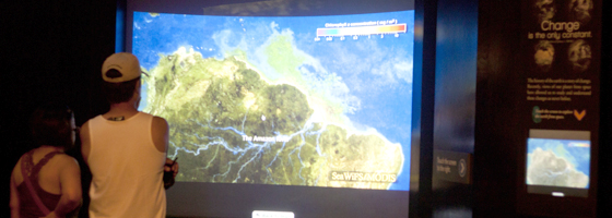
Check out the dramatic images from space at the Museum's newest Earth Sciences exhibit. Videos reveal a satellite's view of wildfire, drought, water, extreme weather, and other large-scale changes on our planet. Discover what images from space are revealing about Earth.

In partnership with Earth Knowledge, Inc. and funding from NASA, this new exhibit highlights what scientists are learning about Earth from space. Curious about wildfires? Urban growth? El Nino? Come see the short NASA videos in the cave.
This interactive kiosk and video display completes the Museum's Earth History Room with a dramatic exploration of the most recent natural history of our planet. Since 1959, satellites have been circling the globe taking pictures of Earth. The satellite's eyes, or sensors, can see types of light not visible to the human eye. They help us measure things like the health of ecosystems, the meanderings of ocean currents and changes in weather and climate. Satellites have helped to change our understanding of how the Earth works. Their imagery also reveals the extraordinary impacts we humans are having on the planet.
Visitors to the exhibit are able to choose from short videos about wildfire, drought, water, extreme weather, Earth at night, urban growth and more. Many of the videos are based on images from the Landsat program, a NASA mission to study planet earth which has been running since 1972! The video below highlights some of the critical and fascinating questions which the Landsat program has helped to answer over recent decades.
You can see many more of these videos on the following websites:
This exhibit is based upon work supported by NASA under award #NNX10AK14G. Any opinions, findings, conclusions or recommendations expressed in this material are those of the authors, and do not necessarily reflect the views of the National Aeronautics and Space Administration.


